
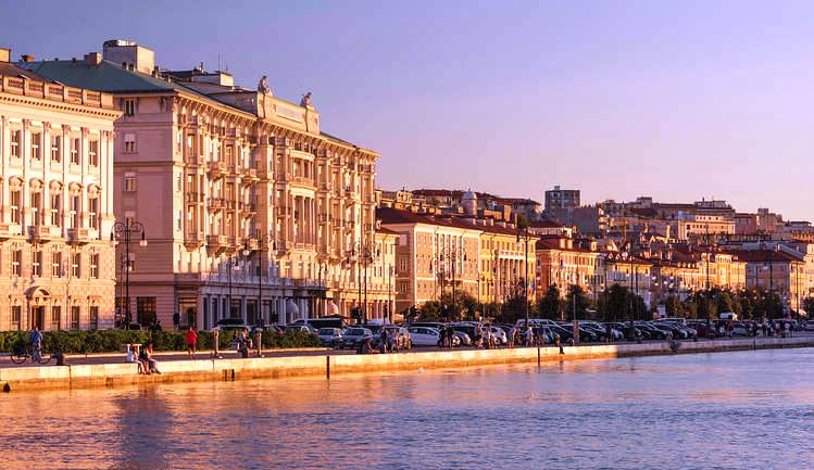
The city of Trieste on the Adriatic Sea isn’t as well-known as most other Italian urban areas. And while places like Rome, Venice and Florence are highly popular tourist destinations, Trieste seems like a comparative backwater by comparison.
It’s a shame, because not only is the city quite beautiful, it’s also one of the most fascinatingly different ones in all of Italy.
Pick up any residential telephone directory for Trieste and read the names of the people inside it. It rivals a phone book from Vienna: What are all of those German, Slavic and Hungarian surnames doing in there?
Here’s your answer: For well over 650 years, Trieste was the main seaport for the Habsburg Empire. The Austro-Hungarian navy was based there, and it was the primary maritime hub for the empire’s 50 million+ inhabitants.
“Vienna on the Adriatic,” indeed.
Following World War I, Trieste was annexed by Italy, whereupon the city went from an important commercial and maritime center to being “just another” middle-sized urban area – among numerous others like it up and down the Italian peninsula.
Trieste’s comparatively inconsequential role today is a vast change not only from recent history, but going back centuries before. As it turns out, threading through the region was one of the key trunk highways of the Roman Empire – one whose existence had been undetected until very recently and whose importance is becoming better understood only now.
A team of Italian and Australian scientists discovered the ancient Roman highway that runs throughout the mountainous limestone landscape just above Trieste … and its discovery would not have happened without the use of LiDAR mapping technology.
LiDAR – an acronym which stands for Light Detection & Ranging – is a system which works on the principle of radar but which uses light from a pulsed laser to measure variable distances to the Earth. LiDAR research is carried out using a laser-firing device mounted to a helicopter. Firing four or five laser shots per square meter over a survey area will measure detailed distances.
Combining LiDAR-generated data with GIS (geographic information system) technology, the distance data enables the creation of three-dimensional information which can reveal otherwise-hidden formations.
In the case of the ancient Roman road above Trieste, the etched lines of the road are just tens of centimeters deep — but they stand out clearly in the images created using the LiDAR technology. Here’s what it looks like:
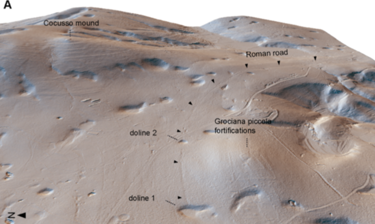
The scientific team had decided to survey the entire region after discovering several ancient Roman military fortifications in the area. It’s likely that the newly discovered highway had connected these fortifications along the Adriatic coast.
After realizing that they were looking at the contours of an ancient road, teams of researchers ventured out to hunt for artifacts – timing their excursions to periods just after heavy rainfalls when the landscape would be more prone to reveal them.
In the finest tradition of “getting their hands dirty,” the researchers uncovered more than 200 Roman shoe hobnails along the highway – particularly those linked to the heavy-soled military sandals worn by Roman soldiers known as caligae.
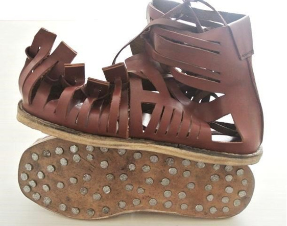
Hobnails are short nails that were inserted into the bottom of the Roman military shoes to provide traction and increase durability. Additional follow-up research has determined that the artifacts likely date to the time of the Roman Empire’s Gallic War.
The Trieste research has helped add to the understanding of the Roman Empire’s military fortifications.
It’s done something else as well: It underscores how completely different the position of Trieste has become in the past 100 years, compared to the several millennia before that.

It’s sometimes worth being reminded how advanced was ancient Rome before “bread and circus” emperors with the mindset of Venezuela’s Hugo Chavez destroyed the economy with taxation and forced farmers to produce below cost, in hopes of pleasing volatile urban masses.
Rome’s economic decline was precipitous and measurable in the few hundred years following by the vastly reduced number of sunken ship cargos carrying goods. Too bad we can’t come up with a real window on the past and see traffic on that newly discovered road. But it is worth seeing what once was, what heppened to it, and what the lesson is for us …